Aerial · Drone services for golf courses

See the whole coursefrom above.

Walk the three greens that need you, not all eighteen. One flight reads the turf across every fairway, green, and tee for your superintendent, shoots the hole-by-hole media the front office puts on a membership drive, and maps the whole course. Same aircraft, same morning, all to one shared folder.

  • Superintendents
  • GMs & owners
  • Membership marketing
  • Tournaments
  • Course renovation

Turf health imagery · course & grounds · Demonstration captureOne flight reads the whole course

What you get

Everything a course buys from the air, in one visit.

A superintendent wants turf data. The GM wants media. Whoever's costing the next renovation wants the lay of the land. One aircraft carries both a high-resolution camera and a multispectral camera, so a single morning on your course delivers all of it, and you write one purchase order, not four.

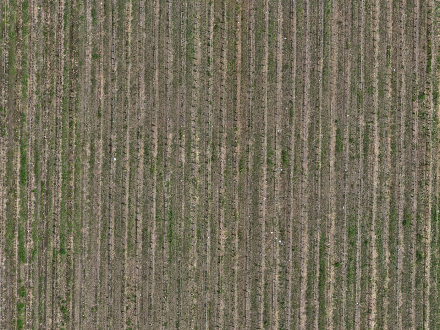
Turf-health multispectral mapping

The same five-index relative-vigor read we run on vineyards and orchards, pointed at your turf: fairways, greens, and tees mapped in one dated, georeferenced pass. Your superintendent sees stress patterns across the whole course instead of walking it green by green, and the thinning patch on 7 shows up as a zone on a map while there's still time to act.

You receive: five-index relative-vigor maps · georeferenced zone maps · plain-language report for the superintendent & agronomist

Aerial course photography & cinematic flythroughs

Hole-by-hole and signature-hole aerials, a full cinematic course flythrough video, and short vertical social cuts for the channels your members and visitors actually scroll. The media that anchors a membership drive, a tournament page, the course website, and the destination feature: the course shown at its best, from angles no ground camera reaches.

You receive: signature-hole aerials · full course flythrough · short social cuts

Hole-by-hole mapping & yardage visuals

A single stitched straight-down orthomosaic of the whole course, plus per-hole top-downs that show each hole's shape, hazards, and lines in one clean view. The practical base imagery a course guide, tee-sign, scorecard, or planning conversation is built on, drawn from the same georeferenced capture as everything else.

You receive: orthomosaic course map · per-hole top-downs for guides & signage

Drainage & terrain visuals

Elevation and contour visuals across the course, plus surface-water flow paths that show where water gathers and runs after rain or irrigation. The topographic picture your team and your contractor work from when planning drainage fixes, a bunker rebuild, or a renovation: where the low spots are, where water wants to go, and how the ground actually lies.

You receive: elevation & contour visuals · surface-water flow paths for planning

Optional interactive 3D course record

If you want it, an interactive 3D twin of the course reconstructed from the same flight: orbit a hole, look at a green complex from any angle, and keep a dated 3D record of the course as it stands today. Useful for renovation planning, showing the course to a board or a membership, and tracking how the property changes over the years.

Optional add-on: interactive 3D course twin · interactive 3D via Sketchfab

Turf-health mapping · for the superintendent

See the weak corner before it browns out.

From a cart you see the green in front of you. From the air, anchored to a reflectance panel, you see every fairway, green, and tee at once: where the canopy is strong, where vigor falls off, and which spot to check first on the morning walk. Five indices that cross-check each other, so a zone reading low across several is a stronger signal than one that shows up alone.

Multispectral relative-vigor map over rows, green higher-vigor through orange lower-vigor zones; a demonstration of the same five-index read used on golf turf. RGB orthomosaic of the same ground in Summerland, BC.

Demonstration capture · vineyard block Drag & switch indices · the same read maps your turf

Each multispectral flight reads the turf across NDVI, NDRE, GNDVI, OSAVI, and LCI. A reflectance-panel capture is part of every flight, so the indices read against the same reference each time, comparable across dates and across the course. Everything arrives as a georeferenced map set and a plain-language report your superintendent can open beside their own scouting notes and their agronomist's.

Who it's for

One course, four people who all need the view from above.

A golf course is run by people with very different jobs, and a single flight serves all of them. The superintendent reads the turf, the front office sells the place, and whoever's planning the next renovation gets the lay of the land.

SUPERINTENDENTS

Superintendents

A whole-course read on turf stress without walking every green, plus a dated record you can set this season's flight against last year's. Relative-vigor maps and zone maps that point you to where to look first, captured the same way each time, so you're comparing the course to itself, not to the light.

GMS & OWNERS

GMs, owners & marketing

Course media that actually sells: signature-hole aerials, a cinematic flythrough, and social cuts that fill a membership drive, a tee-time campaign, and the course website. The kind of footage that makes a prospective member picture themselves on your first tee.

TOURNAMENTS

Tournaments & events

Aerial coverage and a course flythrough for a tournament page, sponsor decks, and event promotion: the course shown the way broadcast shows it, scaled for your own channels. Captured around play and staged grounds, never live crowds.

RENOVATION

Course renovation planning

The orthomosaic course map, elevation and contour visuals, and surface-water flow paths your team and your contractor work from when planning drainage, bunkers, or a redesign. The topographic picture of how the ground actually lies.

Straight talk on what this is

Data for your team's call, not ours.

The turf-health maps are relative-vigor maps showing observed vigor variability, prepared for your superintendent and agronomist to interpret. They point to zones worth a closer look, never a diagnosis or a treatment prescription. The drainage and terrain visuals are topographic data for your course's own planning, not an engineering assessment. Every flight is planned against current airspace through NAV Drone and timed around your tee sheet, so the round keeps moving and any airspace step surfaces at the scope call, not on capture day.

Request a quote

See your course from above.

Tell us how many holes, what your superintendent wants from the turf maps, and what the front office needs for marketing. We'll scope the flight around your tee sheet, once, or as a seasonal program you set the schedule for.

Every inquiry gets a reply within one business day.