Case study · Blair Street 2

One capture. Every deliverable.

One planned flight over a single Summerland property. Six thousand-odd images, each one locked to a corrected position. We processed the whole job in-house, and that one capture became a 3D house mesh, a classified point cloud, a zoomable orthomosaic, and a rendered flythrough. Here's how it actually went, stage by stage.

  • 5.3 ac
  • 6,052 RTK images
  • 100% RTK FIX
  • Summerland BC
Rendered view of the Blair Street digital twin: red-tile-roofed house with vineyard rows rising on the hillside behind it, Summerland BC.

Blair Street 2 · Summerland BC Rendered from 6,052 RTK images

The capture, stage by stage

Six stages, one flight, real numbers.

No re-flights, nothing stitched together from separate jobs. Everything below follows a single capture from the first phone call through to the walkthrough. Every figure on this page is measured, not estimated.

The brief

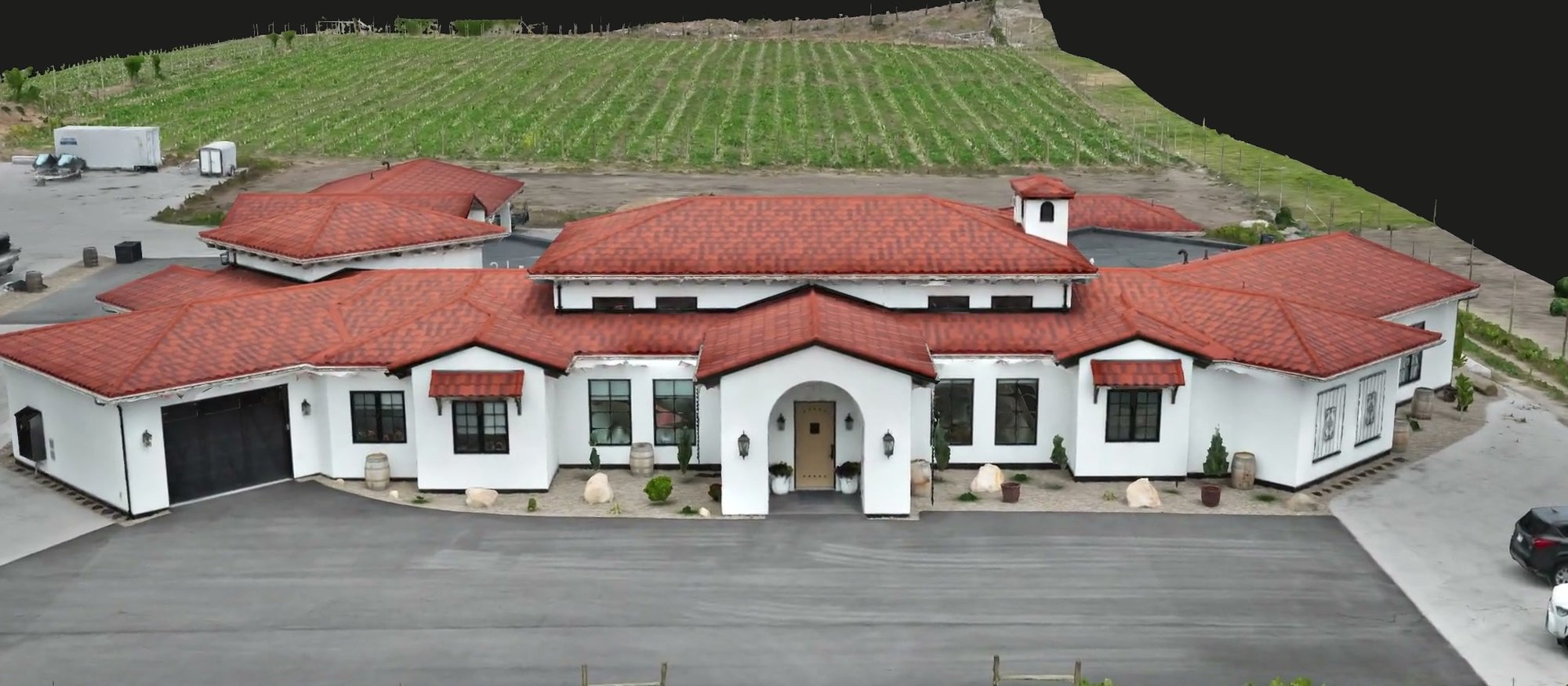
A 5.3-acre Summerland property: house, driveway, grounds, and the vineyard hillside rising behind it. We wanted to put the full pipeline through its paces on one site. Capture it once, then see how many separate deliverables a single good flight can support. One property, every output, no shortcuts.

The site: 5.3 acres · house, grounds & vineyard slope · Summerland BC

Flight plan & airspace

We planned the mission in NAV Drone against current Canadian aviation rules before anything left the ground. Overlap, altitude, and flight lines were set to carry both the wide property context and tile-level roof detail in one pass. Airspace got checked at planning, not on the day.

Planned in NAV Drone · flight lines set for full coverage and close detail

Capture day

One planned flight produced 6,052 images, each frame georeferenced as it was taken on an RTK positioning workflow. The result on the day was 100% RTK FIX. Not float, not a single dropped frame. That's the difference between a pretty picture and data you can actually measure from later.

6,052 RTK-fixed images · 100% RTK FIX · one flight

In-house processing

The whole set ran through DJI Terra and the QGIS and Blender pipeline on our own machines. That's roughly 25 hours across 46 processing blocks, handled by the same pilot who flew the site. Nothing waited in a third-party queue, and outputs came back georeferenced in NAD83(CSRS).

≈25 h · 46 blocks · DJI Terra → QGIS → Blender · NAD83(CSRS)

Georeferencing accuracy

The finished model lands within 3.6 cm RMSE of where the ground actually is. That's a verified figure from the processing report, not a number we hoped for. That accuracy is what makes the same capture trustworthy as a measurement source, not just something nice to look at.

3.6 cm georeferencing RMSE · verified, not estimated

Delivery & walkthrough

The outputs landed in a shared folder with interactive 3D you can open in a browser, plus a walkthrough of what the data shows. Everything below this point is a real deliverable from this one capture. Load each one and look around.

Shared client folder · interactive 3D · walkthrough of the data

Still from the rendered Blair Street flythrough, showing the red-tile-roofed house and grounds with the vineyard hillside rising behind it, all reconstructed from the one capture.

Rendered flythrough · Blair Street twin Demonstration capture

What came out of it

Four live deliverables, one capture.

These are the real outputs from the flight above. It's the interactive 3D a client gets, loaded straight from our own Blair Street capture. All of it came from that one flight.

3D photogrammetry mesh of the Blair Street house and grounds. Press the button to load the interactive model.

House & grounds · Photo mesh 2K textures · RTK

  • From this capture
  • Interactive 3D
  • Photo mesh

The house, as a 3D mesh

A photogrammetry mesh of the house and grounds, built from the same 6,052 images. Drag to orbit, scroll to zoom. This came from that one capture.

Point cloud of the Blair Street property rendered as a million coloured points. Press the button to load the interactive view.

7,998,120-point web preview Ground / above-ground · LAS

  • From this capture
  • Classified point cloud
  • LAS

The point cloud, classified

An eight-million-point web preview of the LAS deliverable. Switch between true colour, ground / above-ground classification, and elevation. This came from that one capture.

Orthomosaic of the full Blair Street property, house and driveway in crisp top-down detail. Press the button to open the zoomable map.

Zoomable orthomosaic · Full property · 5.3 ac 0.3 cm/px delivered · RTK

  • From this capture
  • 0.3 cm/px delivered
  • Full 5.3 ac

The orthomosaic, zoomable to tile level

The full 5.3-acre property as a top-down map you can zoom into 0.3 cm/px delivered pixel detail. That's close enough to read roof tiles. This came from that one capture.

Rendered flythrough · 57 s From the photogrammetry twin

  • From this capture
  • Rendered flythrough
  • 57 s

The flythrough, cut from the same model

A 57-second camera path rendered straight through the photogrammetry twin. It's marketing footage you can't get from a flat photo. This came from that one capture.

How every job runs

The same pipeline, on every site.

Blair Street wasn't a one-off setup. It's the standard pipeline, run end to end. Here are the three stages that make a single capture worth this much.

Captured to a documented standard

RTK positioning on every flight, planned in NAV Drone, with GCP targets placed where the job calls for independent ground reference. That's what lets the data hold up as a measurement source, not just a photo.

What you walk away with: data captured to a documented standard

Processed in-house, by the pilot who flew it

DJI Terra through the QGIS and Blender pipeline on our own machines. Nothing waits in someone else's queue, and georeferenced outputs come back in NAD83(CSRS).

What you walk away with: georeferenced outputs in NAD83(CSRS)

Delivered so you can open, share, and act on it

A shared client folder, interactive 3D where the job calls for it, and a walkthrough of what the data actually shows. It works exactly like the deliverables on this page.

What you walk away with: deliverables you can open, share, and act on

Questions & answers

About this capture.

Is this real client work?

No. Blair Street 2 is our own demonstration capture, shown exactly as a client would receive it. Everything published on this site is our own demonstration capture. Client work appears publicly only with written permission.

Did all of this really come from one flight?

Yes. The house mesh, the classified point cloud, the zoomable orthomosaic, and the flythrough all came from the same 6,052 images captured in a single planned flight. No re-flights, no separate jobs stitched together.

What does the 3.6 cm RMSE figure mean?

It's the georeferencing root-mean-square error from the processing report. In plain terms, it's how closely the finished model lines up with where the ground actually is. It's a measured figure from this capture, not an estimate, and it's what makes the orthomosaic trustworthy as a measurement source.

Request a quote

Every deliverable on this page came from a single flight.

Tell us about your property and what you need to see. Every project starts with a short scoping conversation about what you need, what we'd fly, and exactly what you'll receive.